
A brief history of Radstone Road, Brackley, Northamptonshire.
Ten years ago; Radstone Road was a well-constructed, quiet road at the Eastern edge of Brackley. It had a small soap-works at its southern end, leading into a quiet country C road at its northern end. It rarely experienced heavy traffic, other than on the Formula One weekends at the nearby Silverstone race track, with refuse lorries being the biggest, most frequent HGV usage, with about ten journeys a week.
Today the carriageway is totally shot, with a smear of slime everywhere when it’s wet, and dust-storms when it’s dry, carrying over 200 lorries a week.
With Northamptonshire County Council financially and morally bankrupt, what is the future for the people living on this road?
The Radstone Road ten years ago enjoyed the same quality of construction as similar roads in Brackley such as Humphries Drive and the Halse Road from Pavillions Road to the town limits. Now both those roads are virtually in perfect condition, while Radstone Road needs to be totally reconstructed, from back of path to back of path.
So how can three very similar roads, meeting similar traffic requirements, now be so different?
The answer lies with planned changes to Brackley, looking towards required expansions, and at every stage, making incredibly bad, short term decisions.
When new housing was built either side of the Radstone Road about twenty-five years ago, the whole structure was rebuilt, with implied junctions, needing build-outs to slow down traffic, with priority to the estate roads on the eastern side.
Those build-outs are poorly signed, lit, designed and maintained, leading to regular accidents, invariably caused by people driving straight on southbound, colliding with cars driving round to the right northbound.
Ten years ago; the furthest north extent of Brackley on the Radstone Road, was John Clare Close to the East, and Oak Road to the West.
Then the ‘Radstone Fields’ development was planned, creating a new Roundabout and new infrastructure.
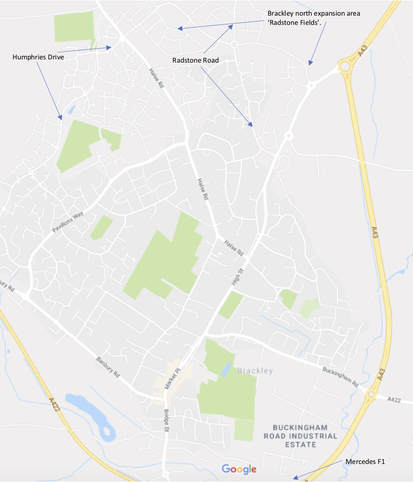
Figure 1. Map of Brackley highlighting places of interest within this blog.
Today the carriageway is totally shot, with a smear of slime everywhere when it’s wet, and dust-storms when it’s dry, carrying over 200 lorries a week.
With Northamptonshire County Council financially and morally bankrupt, what is the future for the people living on this road?
The Radstone Road ten years ago enjoyed the same quality of construction as similar roads in Brackley such as Humphries Drive and the Halse Road from Pavillions Road to the town limits. Now both those roads are virtually in perfect condition, while Radstone Road needs to be totally reconstructed, from back of path to back of path.
So how can three very similar roads, meeting similar traffic requirements, now be so different?
The answer lies with planned changes to Brackley, looking towards required expansions, and at every stage, making incredibly bad, short term decisions.
When new housing was built either side of the Radstone Road about twenty-five years ago, the whole structure was rebuilt, with implied junctions, needing build-outs to slow down traffic, with priority to the estate roads on the eastern side.
Those build-outs are poorly signed, lit, designed and maintained, leading to regular accidents, invariably caused by people driving straight on southbound, colliding with cars driving round to the right northbound.
Ten years ago; the furthest north extent of Brackley on the Radstone Road, was John Clare Close to the East, and Oak Road to the West.
Then the ‘Radstone Fields’ development was planned, creating a new Roundabout and new infrastructure.
Figure 1. Map of Brackley highlighting places of interest within this blog.
Poor decision one: Power cables to what is now the Mercedes F1 headquarters
The formula one team to the south of Brackley has been incredibly successful in its last two manifestations as Brawn then Mercedes, repeatedly winning both the driver and team and team championships.
Shortly after the F1 HQ was built, they needed access to three large supply phase electricity, as they no longer wanted to rely on the nearby Leyton House wind tunnel.
The 132,000 KW power lines with a transformer station is positioned next to the Radstone Road, about half a mile north of the Brackley town limits. It was decided to take those cables the whole length of Radstone road, then down to the A43, then alongside it, to the Brackley side of the road.
Those cables were placed in an impressively deep trench, which at the time looked like it was very well reinstated. However, it is that trench which is the cause of virtually every defect in the carriageway, kerb and footways today.
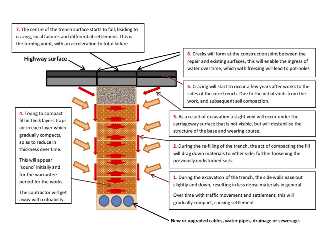
Figure 2. Cross section of the trench, later found to be supplying Mercedes F1 HQ.
Prior to the work being carried out; the Radstone Road was in a virtually pristine condition. For a few years after the trench works, the carriageway and footways still were very good.
In hindsight, a far more effective and societally cheaper route for these cables would have been across the fields towards the A43, joining the road near the roundabout in the NE corner of the provided map.
Poor decision two. The District plan
The decisions regarding the developments to the north and east of Brackley have teetered on several national initiatives, at one time there was a probable reopening of one of the railway lines with a freight depot near Brackley, cutting across the NE corner of the map, within 200m of the Radstone Road.
When that was abandoned the initial alignment for HS2 took it within 800m of the same line, but was later shifted further north, nearer to the hamlet of Radstone.
With this came the consultations for the local plan and Brackley Masterplan, which included several ridiculous ideas to move the only senior school, encouraging a melt-down in local traffic movements.
However, none of these plans suggested the linkage of the A43 to the A422, creating a trunked ring road around Brackley, thereby defining the future scale of the town, and greatly reducing through traffic movements.
These plans did confirm previously defined expansion areas to the north and east which have been implemented and continues to expand, potentially unrestrained.
Poor decision three. Infrastructure
The expansion into ‘Radstone Fields’ has been probable for a very long time. When the Gas, Water, Sewerage, Drainage, Electrical, Phone and communications cables were originally installed along Radstone Road, it was 98% certain that further development was going to occur to the North.
However, all the supplies installed were for the planned immediate capacity, with virtually no spare capacity!
The difference in ‘pipe-size’ for 110% of now, to 200% of now, is about 30% greater diameter. The costs to install ‘now needs’ to ‘greatly increased needs’, would be around 25% more, for slightly wider trenches, and slightly bigger hardware.
Radstone Road has been dug up at least once, for virtually every one of these services and three times for gas, (due to incompetent workers who were unsupervised).
While the permissions for construction are mainly authorised by the County under the New Roads and Streetworks Act (NRSWA), they were either never, or rarely managed. Even when I sent County Engineers photographic evidence of the incorrect methods deployed while work was being carried out.
Poor decision four. Transportation management
Northamptonshire Council are now heavily impacted by budget cuts, with the lowest central government support across the UK. However, years ago they were not supervising new works and NRSWA correctly, leading to failures of assets within five of the planned 25-year lifespans.
Roads initially built as an estate cul-de-sac, have been expanded into through routes, then made into bus routes. These are narrow roads, designed to take a few hundred HGV’s a year, now redefined to take hundreds a month.
The developers built them to lower standards of: thickness, materials and compaction than specified, then the county increased utilisation by heavier vehicles, such that the axle loadings expected in 25 years, would be exceeded in five!
On one occasion I asked why a four-phase traffic management system was in place. The county responded saying no road works were authorised but didn’t come on site to check this out. The contractor felt confident to open up two roads, with traffic lights, NOT expecting the County to care.
On another occasion I reported that both excavation and refilling were sub-standard. No one came out!
When the ‘Radstone Fields’ development started, Radstone Road was defined as the construction access route.
This was a road designed to take say two hundred cars a day, with no more than forty HGV’s a month, none of them over 26 Tonnes.
When this decision was taken, the Mercedes trench was already starting to fail, and until very recently about thirty lorries a day travelled north to the site full of building materials, often weighing up to 40 tonnes, and a similar number of spoil lorries headed south.
Each month the road took more very heavy traffic than it would have normally taken, (was designed to take) in ten years.
Poor decision five. Highways management; Street Lighting PFI.
Northamptonshire decided to enter into a PFI deal to replace all street lighting, to move from numerous sodium lights, to fewer LED ones.
This entailed digging up all the old columns, many of which were relatively new, most having a probable twenty-year lifespan when removed and thrown away, opening up trenches for the lighting cables, and installing new columns.
The environmental aspirations are entirely correct. Lower energy, less light pollution and longer lantern life. However, this simply accelerated the demise of the highway structure. With an interesting maze of openings near one another, often undertaken at the same times, with gas works on one side of the road and street lighting on the opposite footway. Cars and lorries struggled to get through, pedestrians couldn’t get through! Damage created by lorries parked on the footways during that work have never been repaired.
The PFI included new illuminated signage, these were clearly designed only on a map, with no site visits ever undertaken. Now a ‘Give Way in 100 yards’ sign is placed within the canopy of a chestnut tree, such that you can’t see the sign other than for four leafless months of winter.
Another ‘Give Way’ sign is placed just around the corner from the junction, behind an existing tree and high hedge. That sign is impossible to see from the required ‘Give Way’ road, and now is part of the problem for accidents.
There are numerous examples where opportunities for a single post with multiple uses has not been carried out, adding to both costs and clutter. Had the contract been professionally managed it would have been more effective in meeting traffic and pedestrian needs, and would have cost millions less across the County.
Poor decision six. Works control
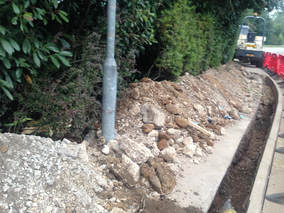
The second set of Gas works in the last five years involved laying a new local supply, mainly within the footway, right alongside the back of kerb.
The contractor cut the inner edge with a circular saw, then used a mini-excavator mounted on the path, to dig out the new trench. Storing the excess spoil half on the path, and half into private land, including hedges.
This methodology had two bad draw-backs, it ripped all the bedding and backing of the kerbs out, destabilising the kerbs completely. It also totally destroyed the hedges in place, which have never grown back.
To make matters worse, this trench is alongside the ‘Mercedes trench’ from nine years ago. That trench was already caving in due to insufficient compaction, this sister trench then loosened material to one side, accelerating the failure process.
Figure 3. Local distributor gas trench, alongside Mercedes trench, ripping out kerb bed and back.
Again; the Council officers were informed of this, and even sent pictures while the damage was being carried out. No one showed any interest, nor would they furnish contact details for their cowboy builders.
Within 18 months the trench was failing, the gas supplier resurfaced some, but have left the unsupported, irregular kerb unattended. Again; the Council were informed of the kerb issue, but didn’t act on it. This road was the preferred route to the development site, until very recently, despite the new distributor road, Poppyfields Way, being built. (But not on most supplier Sat Nav’s)
The council will fill a pothole every few months but turn a blind eye to the fact that the kerbs have sunk, and that drainage gulleys are now mainly at channel high points, leading to the highway being constantly covered in slime when wet, leading to virtually all water draining into the carriageway sub-strata, accelerating its decomposition.
In the summer, the paved footway could be mowed, as so much grass and weed has taken root in the surface as it is never swept of cleansed.
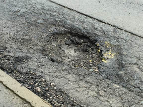
Figure 4. Typical failure mode for the Mercedes trench, due to secondary upheaval.
Poor decision seven. Highways design
In general; the ancient farm hedges have been left in place either side of the highway. These hedges are mainly ‘owned’ by the householders, although some are clearly in the highway.
Most houses have brick walls or high fences to define the maintained part of their property, with the hedge being outside that area. Most householders don’t maintain the hedge.
The county doesn’t maintain the hedge, the Town Council maintain theirs; but not well.
The county also designed two build outs, to created inferred junctions, which have large shrubs and trees planted in them.
The County has never managed to cut back all shrubs in their ownership to ensure free pedestrian access along the paths.
At best they will cut these back, less than once a year, to the back of path. Within three months the path can be 100% obstructed.
This is a route that is inspected as ‘being fit for purpose’ every month, and yet this serious breach of health and safety is virtually never acted on.
The County and District (South Northants), should not design infrastructure, unless they can ensure it is maintained as fit-for-purpose!
Poor decision eight. Highways maintenance
The highway white lines in the Radstone Road have failed quickly due to increased usage and the rapidly failing sub-strata. Interestingly last February some thermoplastic relining was being carried out after 22:00 hrs in sub-zero weather.
I informed the county that this was that late in that weather, advising that it would fail, which it did within days. So now, more than a year later, those essential lining repairs are not in place.
That’s two reasons the county are aware of why a serious RTA will happen on this junction.
The council is now cash strapped, so will not repair even category A defects on this distributor / C Road for 40 days.
They then repair 98% of defects with asphalt suitable for a stable base course. This highway is failing fast. Those patches break out within days, so they patch the same areas repeatedly.
Taking 40 days to affect a repair has two significant issues, a) both the hole and risk get bigger over time and b) the council will be liable for any injury or accident that occurs in the meanwhile without legal cover.
When they repair, they usually only repair the hole originally reported, but will ignore the dozen or so others around the edges. Thus; significantly increasing the cost of repair per hole.
Poor decision nine. Highways Inspections
Radstone Road is inspected via two approaches, the first is course visual, where an inspector is driven along the highway quite slowly, recording all serious defects as they go on a monthly basis, the second is via a walked fine visual, for the ‘town length’ on a six-monthly basis.
A freedom of information request, gained these details for the whole of Brackley, in January 2018.
The course visual and the fine visual results are statistically impossible to both be correct.
The course visual inspections do not tie up with known repairs undertaken, such as repairing nine notifiable defects in September 2017.
The course visual inspections show exactly the same level of white line road marking quality, irrespective of what is in place.
There is a length of Radstone Road between Poppyfields Way and the next roundabout which is basically destroyed, that doesn’t yield a defect.
The reported defects from the fine visual reports, haven’t resulted in any necessary works to make the highway legal.
Trips in the path, or in adjacent kerbs are not recorded.
30mm deep slime areas on the footway, behind a kerb with a razor edge trip are not defected.
The failing trench, in places 125mm below original height are not defected.
The ineffective drainage system, leaving standing water whenever it rains, is not defected.
The road-signs buried in the depths of large existing trees, or behind hedges are not defected.
The road markings that scrubbed away within a week of being painted are not defected.
We have absolute PROOF that highway inspections to meet the legal requirements of a highway authority are NOT conducted by Northamptonshire County Council.
Required action
Northamptonshire Council and South Northants Council have worked together to destroy the fabric of Radstone Road, damaging personal property, and reducing the value of housing, while causing dust and slime for secondary health issues.
The people of Brackley require the Councils to use their Section 151 monies obtained from these developments to reconstruct the whole length of Radstone Road from Northampton Road to the edge of town, to be no worse than it was ten years ago, prior to them conspiring by design, to destroy the highway.
The people of Brackley require the Councils to use their Section 151 monies obtained from these developments to reconstruct the whole length of Radstone Road from Northampton Road to the edge of town, to be no worse than it was ten years ago, prior to them conspiring by design, to destroy the highway.
 RSS Feed